MSL in Aviation: Mean Sea Level Explained 2026
Aug 04, 2026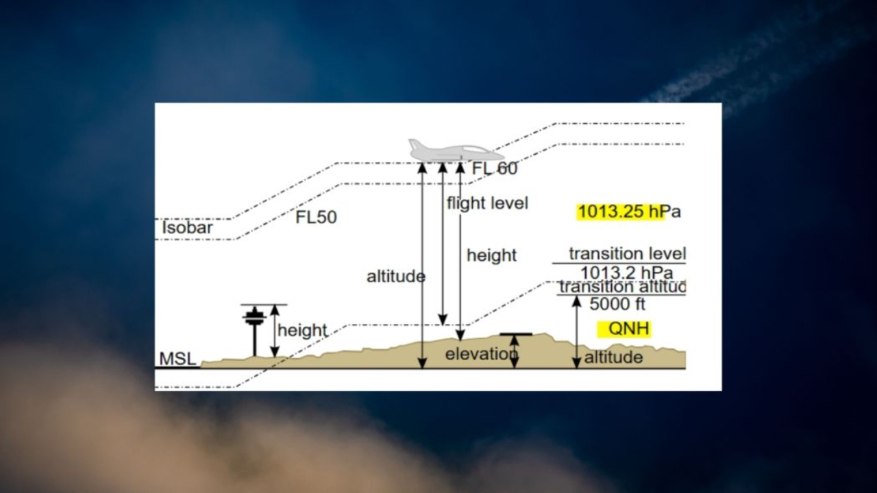
Understanding MSL in aviation is crucial for safe flying. Mean Sea Level (MSL) serves as the universal altitude reference pilots and air traffic controllers rely on to navigate skies safely. Discover how MSL differs from AGL, why it matters, and how mastering these concepts ensures precise altitude awareness every flight.
What Is MSL in Aviation?
Mean sea level or MSL for short is the average level to which the world's oceans settle down over the long term. We're talking smoothed out to the point where tides, storms and seasonal changes don't even register.
In aviation, MSL is the reference everyone uses to pin altitude to. When a controller or a chart tells you "3,000 feet MSL" it means 3,000 feet above that sea level marker and that's regardless of what's lying beneath the aircraft, be it mountains, skyscrapers, or nothing at all.
For pilots, air traffic control, aeronautical charts and even approaches for landing in thick fog all work with msl altitude. That's because it gives everyone a consistent point of reference no matter where they are on the map.
It's the opposite of AGL (above ground level) where the focus is purely on how much space is between the plane and the ground beneath. In reality, both references are important but MSL is the one thing that ties everything together neatly.
It's worth taking a closer look at why the difference here matters. Take an airport in Denver, for example. It sits at a bit over 5,000 ft. Now if a plane is flying at 7,000 ft msl it's only 1,700 ft above ground level.
But in Miami where the airport itself is only about 10 ft above sea level, that same 7,000 ft msl is almost 6,900 ft clear of the ground. The same altitude - but a completely different story in terms of clearance.
How Mean Sea Level (MSL) Is Determined

Sea level is not constant. Tides rise and fall daily, storms push water inland, and ocean temperatures shift with the seasons. To create a reliable reference for aviation, scientists calculate msl mean sea level using tidal data collected over 19 years a full tidal datum epoch that averages out all these fluctuations. The U.S. National Tidal Datum Epoch, for instance, is anchored to observations recorded between 1983 and 2001.
Beyond local tide gauges, global geodetic models make msl useful worldwide. The WGS-84 system, introduced in 1984 and significantly updated around 2004, includes both a mathematical model of Earth's shape (the ellipsoid) and a geoid surface that approximates mean sea level across continents and oceans.
Modern GPS technology still references this framework when converting satellite-derived geometric height into an average sea level altitude that pilots can actually use.
One common question: does rising sea level affect aviation? Technically yes, but msl changes less than a tenth of an inch each year a negligible amount compared to the thousands of feet that separate a plane from the surface.
The difference between the "instantaneous sea level" at a beach on a given afternoon and the long-term mean sea level pilots rely on can be several feet, but the averaged datum remains stable enough for safe flight operations.
MSL vs AGL: Key Differences for Pilots
Msl altitude is essentially the distance above the average sea level but let's get practical. Agl ( Above Ground Level ) is the actual height of the aircraft from the ground right below it. Where Agl really gets interesting is that it can change all the time, depending on where the ground is below you.
So, if you're flying over a mountain ridge, your Agl drops right down, and if you're flying over a valley even if your altimeter reading is the same as before your Agl shoots up ! That's important because Agl is all about how high your aircraft is above actual ground.
Lets take a couple of real-life situations for example. An airplane at 10,000 feet is going over Denver, which has an elevation of about 5,280 feet so that means the plane has about 4,720 feet above the ground.
Now, picture a drone which is only allowed to fly 400 feet above a flat field that is 600 feet above sea level that drone would be up at a 1,000 feet altitude when we talk about sea levels.
The difference between Msl and Agl is really important when you're flying. If you are not aware of this difference you can get yourself into some real trouble especially when it comes to avoiding obstacles in mountainous areas.
Just think about it like this : if you're flying at 3,000 feet msl and you think you've got plenty of clearance, but the ground beneath you has suddenly risen to 2,500 feet your actual Agl is only going to be 500 feet.
Pilots and air traffic controllers are always using either Msl or Agl depending on the situation: controllers will give you airspace altitudes and separation in MSL, but sometimes you have to reference Agl values in other situations like obstacle clearance.
Altimeters and Altimeter Setting: AGL or MSL?

The standard pressure altimeter in your cockpit reads altitude relative to mean sea level when set correctly. Aircraft altimeters are typically set to local pressure to display msl altitude.
By dialing in the current altimeter setting the local barometric pressure from a METAR or ATIS broadcast the altimeter displays the airport's field elevation in feet msl while you're on the ground. In flight, the instrument shows indicated altitude, which corresponds to your true altitude above mean sea level under standard conditions, as explained in standard temperature and pressure aviation.
When above 18,000 feet msl, altimeters use a standard pressure setting of 29.92 inHg. At that point, pilots fly flight levels rather than specific msl readings, but the reference is still a standardized sea level datum, not the ground.
If a pilot were to set the altimeter to zero on the runway instead, the instrument would show height above ground level for that location only and would quickly become inaccurate as terrain changes along the route.
Radar altimeters provide Agl readings by measuring distance to the ground using radio waves. A radio altimeter gives true height above the surface below, which is invaluable during instrument approaches and low-visibility landings.
However, it only tells you about the terrain directly beneath the aircraft at that instant, not what lies ahead.
A scenario worth remembering: flying toward an airport where pressure is dropping, a pilot who fails to update the altimeter setting to local QNH may read msl altitude that's higher than true altitude, reducing actual obstacle clearance without realizing it. This is why updating your altimeter setting is a critical habit.
MSL, AGL, and Sectional Charts (Airspace and Obstacles)
Aeronautical charts list terrain elevations and obstacles in msl as the default. On VFR sectional charts, the FAA Aeronautical Chart Users' Guide states that unless otherwise noted, all altitudes indicate feet above mean sea level.
Airport elevation printed near the airport symbol is always in feet msl. Obstruction icons for towers and wind turbines often show two numbers for example, "1049 (1036)." The first figure is the top of the structure in feet msl; the number in parentheses is its exact height in feet Agl.
This lets pilots judge both the maximum elevation figure they need to clear and how tall the structure actually is relative to the ground beneath it.
Airspace boundaries follow similar conventions. Class B, C, and D controlled airspace limits on a chart are labeled in feet msl, such as "SFC to 10,000 MSL." However, Class E transition areas use Agl references the magenta-shaded areas on a sectional aeronautical chart legend indicate where Class E begins at 700 ft Agl.
If the ground elevation at that location is 800 feet msl, Class E starts at 1,500 feet msl there. Pilots must convert mentally to maintain safe terrain clearance.
FAA exam questions regularly test your ability to distinguish msl or Agl on chart legends and obstruction icons. Practice with current sectional charts to build this skill.
When to Use MSL vs When to Use AGL in Operations
Both msl and Agl are really essential, but they come into play in very different situations. Pilots use msl to get a clear picture of where they are. That being said, in order to navigate and to communicate with ATC, it's msl that's the go-to choice.
En-route cruising altitudes like 8,500 feet msl for those flying VFR eastbound as well as IFR minimum altitudes such as MEA and MOCA, and published approach altitudes are all expressed in msl.
And here's the thing, air traffic control will assign an altitude based on msl to keep planes separated and ATC comms always expect an altitude report relative to mean sea level.
But then there are Agl references, and they tend to dominate near the surface. Many regulations stipulate min. safe altitudes in Agl 500 feet Agl over sparsely populated areas and 1,000 feet over congested areas here in the U.S and traffic pattern altitude is nearly always stated as a height above the ground: 1,000 ft Agl over the airport.
And if you're flying into an airport with a field elevation of 1,500 feet msl, that pattern altitude on the altimeter ends up being 2,500 feet msl. For drone pilots and operators, Agl is also the way to go since UAS rules have you limited to flying 400 ft Agl over the surface. Agl is super important when it comes to low-level flight phases like takeoff and landing.
Pilots end up combining both references all the time. For example, if you're crossing a ridge with a known ground elevation of 2,200 ft msl and you need to keep 1,000 feet of clearance from obstacles then you're going to have to climb up to at least 3,200 ft msl to be safe.
And that's exactly why pilots use msl to ensure they've got safe terrain clearance and are avoiding obstacles on every flight.
Instrument Sources of MSL and AGL in the Cockpit
Different instruments provide different altitude references. The pressure altimeter is the primary source of indicated altitude in feet msl when set correctly. An incorrect altimeter setting shifts your apparent msl altitude and implied clearance over terrain a rule of thumb is that 0.1 inHg of error equals roughly 100 feet of altitude error.
The radar altimeter (also called a radio altimeter) provides real-time height Agl directly under the aircraft, most accurate below a few thousand feet. It's common in airliners and IFR-equipped aircraft during approaches.
GPS gives geometric altitude, which avionics convert into an approximation of msl using internal geoid models. Modern glass cockpit displays overlay terrain elevation databases, effectively deriving agl by subtracting terrain from msl.
Terrain awareness systems like TAWS and GPWS use a combination of msl altitude and digital terrain data to warn when height above the ground is becoming unsafe. If any of these systems become inoperative, operators must determine whether the aircraft can still be dispatched by consulting the minimum equipment list.
Msl values are critical for instrument approaches and safety procedures. Picture a night approach over rising terrain: your altimeter displays 4,500 feet msl, but the ground ahead climbs to 3,500 feet msl.
The terrain awareness system alerts you before your Agl drops below safe thresholds preventing the kind of controlled-flight-into-terrain accident that these systems were designed to stop.

Why MSL Matters for Safety, Planning, and Training
Understanding msl measures versus Agl isn't just theory for a written test it underpins every phase of flying. During flight planning, pilots select cruise altitudes based on terrain elevations shown in msl on charts. They identify the highest obstacle along a route, add a safety buffer, and arrive at minimum altitudes that guarantee safe terrain clearance.
In training, student pilots learn to mentally convert between "pattern altitude 1,000 ft Agl" and the equivalent msl number based on the airport's elevation.
Ground school and checkrides emphasize reading charted airspace altitudes, cloud heights, and cloud base references correctly. A common pitfall on the faa exam: treating an agl-based minimum like 500 ft above ground level as if it were an msl number without adding local ground elevation. Another frequent mistake is misreading parentheses on charts and confusing which number represents msl versus agl for towers and obstacles.
Whether you're a student pilot, a seasoned aviator, or among the growing community of drone operators, precise use of mean sea level and above ground level references underpins obstacle clearance, terrain avoidance, and regulatory compliance in every phase of flight.
Practice reading real sectional chart excerpts, quiz yourself on obstruction symbols, and always double-check whether the number you're looking at is msl or agl before you fly.
